This morning was our first heavy frost of the season. We've had a couple of mornings with very light patchy frost, the frost was unmistakable this morning. The low this morning was 29.7 degrees. I don't know if this counts as a killing frost though since we really hovered at or above 30 for most of the morning. The flowers on my deck were covered in frost this morning.
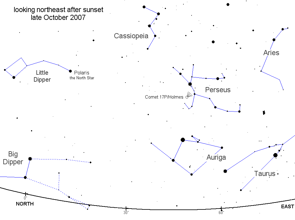
A new astronomical surprise this evening that has even shocked the professional astronomers. Comet Holmes has exploded in magnitude. This article explains that the comet was at a very dim magnitude 17, but has exploded into a magnitude 2 sky object. You can see a star chart giving the location of the comet here. Look for Cassiopea and then down and to the right just a bit. It is in the constellation Perseus. I went out just now and found it in 2 seconds. It is a blurry disk shaped object in the sky. They say that if a tail develops, it will be very short and stubby. We are looking directly at the comet from Earth and the sun is behind us. They say that from the comets point of view, the Earth is only 15 degrees apart.
Monday, October 29, 2007
Sunday, October 28, 2007
Freeze Warning in Effect
 A freeze warning has been issued for the entire area. The low temperature was forecast to be 38 this morning, but the actual low was 31. The forecast low for Monday morning is 31, so I'm going to believe that we may be in the mid 20's. If the temperature does drop that low, a killing freeze will occurr.
Saturday, October 27, 2007
Frost Advisory
 A frost advisory has been issued for the area. Temperatures may drop low enough for some light frost to develop in some areas. The forecasted low is 38 for Sunday morning and 32 for Monday morning.
Thursday, October 25, 2007
Drought Relief

The recent rains have helped relieve the drought. We're still in a drought though. The most recent drought monitor has the NW corner of the county in the "abnormally dry" category. Hopefully, we'll get more rain and we will be completely out of the drought category. This month, we are .28" below normal.
Tuesday, October 23, 2007
RAIN!!
Finally, some decent rainfall across the area. In the last 48 hours, 1.65" of rain has fallen. This is light though compared to what has fallen further south and east of here. Hamilton, Ohio has had at least 3 inches of rain and Cincinnati has had at least 4 inches of rain in the same 48 hour period. There is a chance for rain again on Friday, so hopefully we'll get some more.
Saturday, October 20, 2007
Tornado Outbreak
Our severe weather threat certainly became a reality, but not for the local area. There were 29 tornados reported on October 18 with the closest being along the Ohio River southwest of Louisville, Kentucky and in the northern part of Indiana in the town of Nappanee. The Nappanee tornado was the strongest in the state rating as an EF3. This category of storm has winds up to 170 miles per hour. There are several photos of the storm on my photo blog at http://picasaweb.google.com/Toby.Witt .
On a more pleasant note, the fall color has exploded around here in recent days.
I have posted some photos of this on my photo blog too. Here are a couple of my favorites though.
Well, blogger isn't allowing me to upload photos at the moment, but go to my photo blog to see the photos.
On a more pleasant note, the fall color has exploded around here in recent days.
I have posted some photos of this on my photo blog too. Here are a couple of my favorites though.
Well, blogger isn't allowing me to upload photos at the moment, but go to my photo blog to see the photos.
Wednesday, October 17, 2007
September Review
September turned out to be above normal in precipitation which broke our seven month stretch of below normal precipitation. I have to note though, that since I do not have a rain collector heater, the amount of precipitation collected during the winter months is likely less than what actually fell. Okay, with that said, September was 0.80" above normal in precipitation. We had one good storm on September 8 when 1.19" fell in a 24 hour period. The storm lasted three days with a 72 hour total of 2.53" on September 7, 8, and 9. There were only six days of precipitation during the month.
September ended up being above normal in temperature too. The beginning of the month was quite hot with a reading of 94.7 on the 4th. There were three days of 90 or above. For the month, we were 3.3 degrees above normal.
September ended up being above normal in temperature too. The beginning of the month was quite hot with a reading of 94.7 on the 4th. There were three days of 90 or above. For the month, we were 3.3 degrees above normal.
Severe Weather Potential
 The weather has been anything buy exciting this past summer and now early fall. However, that seems to be changing. A severe weather outbreak is expected tomorrow for Indiana. The SPC has had Indiana in a moderate risk for severe weather on Thursday since Tuesday. That is unusual for a moderate risk to be posted a full 48 hours in advance of the forecasted severe weather. At this time, damaging winds, hail, and tornados are possible late Thursday afternoon and evening. We'll see what comes out of this.
It seems fall has finally arrived here. The weather is cooling off, but we're still above normal. In any case, the fall color has begun to show it's face more and more over the last couple of days. Here are a couple of photos I snapped today of the fall color around the house.


Saturday, October 6, 2007
October Heat
 Is it July or October? If you didn't know any better, you'd think it was July by the heat and humidity that we're experiencing. The high was 87 here ate home today, but 89 in Indianapolis. The Indianapolis high was a record for this day. The old record was 88 in 1946! Here's a map showing just how warm the entire eastern half of the country has been for the first week of October.
Subscribe to:
Posts (Atom)