Monday, May 28, 2007
Summer Humidity
We only had a couple of sprinkles today, but the humidity has made a significant turn for the worse. I mentioned in my post yesterday that the humidity was much more noticeable but the dew point was only in the upper 50's. Today, the dew point was in the upper 60's. It definitely felt sticky and uncomfortable outside. This should last through the week with the possibility of some relief by Friday with the passage of a cold front. This is what is forecasted at least. We'll see what actually happens.
Sunday, May 27, 2007
Rain!
A bit of rain fell yesterday for the first time since May 15. A very thin line of rain moved from Greensburg and trained to the northeast. Several heavy showers moved across the area in this line giving us 0.32" of rain. Another thundershower popped up in the area today, but only 0.03" of rain fell today. Just enough to get things wet. Tomorrow is forecast to have similar weather in the afternoon. We're still quite dry compared to a normal May though. So far we have had a total of 1.10" of rain this month. Normal would be over 4 inches!
Temperatures have been comfortable with not a lot of humidity. Maybe I'm just getting used to it though.
Temperatures have been comfortable with not a lot of humidity. Maybe I'm just getting used to it though.
Wednesday, May 23, 2007
Hazy Conditions Caused by Fires
There was a noticeable haze in the air today. It looked like a very humid July day, but it wasn't very humid today. Instead, the haze came from fires in the southeastern part of the country. There's a bit from the NWS below.
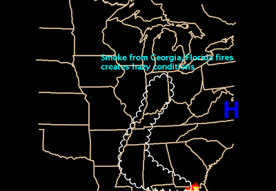
From the NWS in Indianapolis...
You may have noticed the hazy look to the sky on Wednesday. Visibilities were reduced to around 5 miles at times during Wednesday afternoon at the Indianapolis International Airport. The hazy conditions were caused by the wildfires in southern Georgia and northern Florida.
Clockwise winds flowing around strong high pressure off the eastern United States brought the smoke west from the fires into Mississippi and then north through Tennessee, Kentucky, and into Indiana. Visibilities closer to the fires in Georgia and Florida were around 2 miles in smoke. Farther away from the fires, visibilties generally ranged from 5 to 7 miles.

Monday, May 21, 2007
Driest Start to May in 15 Years
From the NWS in Indianapolis...
May 2007 has started out mild and very dry in Central Indiana. The precipitation total during the first 18 days of May 2007 at the Indianapolis International Airport has been a mere 1.07 inches. This is well below the normal value of 2.50 inches for the first 18 days of May. The average temperature for these first 18 days of May has been 67.6 degrees, slightly more than 5 degrees above normal.
So what is the reason behind this dry and mild start? The jet stream, which would typically be over the nation’s mid-section during May, has been displaced farther north. A ridge of high pressure has been present for most of the month across the Midwest, which has shifted the track of low pressure systems (and their rainfall) well north. When cold fronts have approached the area, the high pressure has held them at bay, and the sinking air associated with a high pressure system also acts to dry the air out. The end result is an extended period of sunny and dry weather.
This May marks the driest start to any May in the Indianapolis Area since May of 1992 when the first 18 days brought only 0.88 inches of precipitation. That month finished out with just 1.56 inches of rain, making it the 16th driest May on record. ?wfo=ind
Sunday, May 20, 2007
Dry and Getting Drier
It's been a long while since I posted. There hasn't been a lot to discuss really since the month began. We're started the month off May off very dry and that dry spell has continued. We've only had one significant rain this month and that was on the 15th and 16th when 0.65" of rain fell. Our total for the month so far is only 0.78". The normal amount of precipitation for the month of May is 4.75". The ground is becoming quite dry and I feel we may be in for one of the driest summers we've had in quite some time.
Tuesday, May 1, 2007
Coldest April in a Decade
From the NWS in Indianapolis...
April 2007 will be a month long remembered for its persistent unseasonable chill for much of the early part of the month. This was in sharp contrast to last month, which was the 7th warmest March ever. The following is a summary of the weather conditions observed in Indianapolis during April 2007.
Temperature
The average temperature for the month of April was 50.8 degrees. This was below the normal April value of 52.0 degrees by 1.2 degrees. This was the coldest April since 1997, when the average monthly temperature was 48.3 degrees. Interestingly, every April since 1997 had been above normal for temperatures before this year. April of last year was almost 7 degrees warmer than this year.
The month was characterized by an extended period of late winter chill from the 4th of the month through the 19th. One day during that period saw temperatures above normal. 7 days in a row experienced overnight low temperatures below the freezing mark in Indianapolis. Highs remained in the 30s for 3 days in a row, with April 7 marking the peak of the cold wave. With a high of 32 and a low of 23, the 7th set a record for the coldest high temperature ever recorded on the date. It tied for the 7th coldest day ever recorded in April in the Indianapolis area.
It was the most intense April cold snap in Indianapolis since 1982, but remarkably the whole month only finished out below normal by 1.2 degrees. This was due to the extreme warmth of the first three days of the month, as well as a return to well above normal weather the last few days of the month. The last day of the month brought the only high temperature of 80 degrees or above. March of 2007 saw 3 days with highs in the 80s. Since 1871, only 5 years have occurred when March had more temperatures in the 80s than April.
Precipitation
April 2007 saw 3.30 inches of precipitation measured at the Indianapolis International Airport. This value was below normal by 0.31 inches. This ends the streak of 8 consecutive months with above normal precipitation. The last month below normal for precipitation at Indianapolis was August of 2006.
Snow
While April of 2007 experienced a monthly total of just a Trace, the month was remarkable in the fact that 9 days during the month experienced at least flurries. On average only 2 days in April will experience snow. April 4-9 saw six consecutive days with a trace of snow, tying the longest such streak of its kind.
Warm Weather Continues
The warmth of yesterday carried over to today. We had a lot of sunshine early in the day, but as the day progressed, the clouds began to increase as well. The sun was still able to penetrate the clouds, but the skies were not the crystal clear blue that they were on Monday. A few storms developed in the northern part of the state late this afternoon and this evening, but they moved east. There's still a shield of rain in Missouri crossing into southern Illinois, but it will likely fizzle before it reaches us here. I don't look for a lot of rain over the next couple of days. Let's hope I'm wrong.
Subscribe to:
Posts (Atom)