 I don't think the snow we have will stick around for the next week. There are a couple of chances for more snow between now and next Tuesday, 12/25, but I don't know what they will bring. Here is a map of current snow cover across North America. Good coverage for the middle of December.
Monday, December 17, 2007
White Christmas?
I don't think the snow we have will stick around for the next week. There are a couple of chances for more snow between now and next Tuesday, 12/25, but I don't know what they will bring. Here is a map of current snow cover across North America. Good coverage for the middle of December.Sunday, December 16, 2007
Storm Wrap-up
 Well, this was dissapointing. I guess that's what I get for following the development of a storm for so long. I was expecting about 8 inches of snow out of this storm, but only got half of that. Oh well, there will be others but I won't watch them so closely.
The wind is strong and there are advisories out because of it.
Here are some snow totals from across Indiana.


Saturday, December 15, 2007
Winter Storm Part 2
Things didn't turn out the way I was hoping. The snow continued to fall until about 11:30 when it transitioned into sleet. By 12noon, the sleet was freezing rain and rain. About 3 inches of snow fell during the morning hours, but half of that is gone now after being beaten down by the sleet and melted by the rain. Temperatures rose to 31.5 and held there for the afternoon, but began to rise to 32.4 by 6pm. We have now been holding at 32.1 for the last several hours. They are saying that that winds should shift to the N later this evening and then the temperatures should begin to fall. They are also saying that we will get another 2-4 inches of snow. Hopefully, we'll be on the high end of that and that the snow gets blown around a lot during the day tomorrow.
Winter Storm Warning
A large winter storm is beginning to impact the area with heavy snow, freezin rain, sleet and rain. At the moment the temperature outside is 28 with light snow falling. The snow began to fall at 8am this morning and has continued. I'll paste in a picture from my weather cam below to show what it is like here at the beginning of the storm. The potential exists for us to get about 8 inches of snow out of this storm. Some are saying that freezing rain and sleet will mix in here, but I'm not so sure that will happen. If it does, our snow totals will be reduced. If it doesn't, then I think we may get up to a foot of snow. :-) The winds are forecast to pick up on Sunday, so if that does happen we will have a lot of blown and drifting of the snow. I don't think we'll have a blizzard though. You need heavy snow falling along with strong winds for a bonafide blilzzard and the precipitation will be moving out as the winds pick up.


Saturday, December 8, 2007
Snowfall
The snow that came through early Friday morning left 1-2 inches here, but some areas received up to 4 inches. The temperatures warmed to 34 today which allowed for some snow to melt and become slushy. By 6pm, rain moved into the area from the west. The temperature hovered at 32.2 all evening long and there was some *very* light icing. The trees had a very thin coat of ice, but the road and sidewalk did not have any ice build up. Total rain for the evening was 0.28 inches.
Thursday, December 6, 2007
Here Comes Round 2
The Wednesday morning snow left about 2-3 inches around here. The temperatures dropped through the day also, so the snow that did fall remained on the ground. Because of the fresh snowpack, clear skies, and calm winds, the temperature bottomed out at 6 Thursday mornings. This was the coldest morning since February 2007.

The system that is coming in tonight is forecast to bring another 1-3 inches of snow across the area tonight. The snow should begin around 2am and be finished by 8am.


Tuesday, December 4, 2007
First Snow of the Season Locally
From the NWS in Indianapolis:

First Accumulating Snow of the Season Begins Tonight
Snow will move into central Indiana this evening. This is expected to be the first accumulating snow of the season for central Indiana, with 3-5 inches expected in the northeast tapering to one inch or less over southwestern portions of central Indiana. The snow is expected to be at peak intensity early morning through midday on Wednesday. This will likely cause significant travel difficulties for the Wednesday morning rush hour.
Snow will move into central Indiana this evening. This is expected to be the first accumulating snow of the season for central Indiana, with 3-5 inches expected in the northeast tapering to one inch or less over southwestern portions of central Indiana. The snow is expected to be at peak intensity early morning through midday on Wednesday. This will likely cause significant travel difficulties for the Wednesday morning rush hour.

A winter weather advisory has been posted for the area in anticipation of the snowfall.

Sunday, December 2, 2007
North American Snowcover
The snowcover expands after the most recent winter storm. Here are a couple of maps showing snow cover and snow depth. There are only 150 stations across the US that report snowdepth, so this is why the map is light on numbers. Use both to get an idea of snow cover.

Click on the dark map to see full-size and then you can read the numbers.
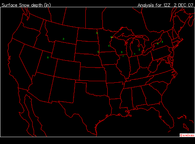

Click on the dark map to see full-size and then you can read the numbers.

Saturday, December 1, 2007
Winter Weather Advisory Posted the Area
I don't understand this. Nothing more than a few pellets of ice have fallen. Temperatures are still below freezing, but *slowly* climbing by about a tenth of a degree every thirty minutes or so.

A winter weather advisory has been posted for Fayette, Union, and Wayne counties in Indiana until 10pm this evening.

URGENT - WINTER WEATHER MESSAGENATIONAL WEATHER SERVICE WILMINGTON OH313 PM EST SAT DEC 1 2007...AREAS OF FREEZING RAIN AND SLEET POSSIBLE THROUGH EARLYEVENING...INZ050-058-059-OHZ026-034-035-042>044-051>053-060>062-020300-/O.NEW.KILN.WW.Y.0006.071201T2013Z-071202T0300Z/WAYNE-FAYETTE IN-UNION IN-HARDIN-MERCER-AUGLAIZE-DARKE-SHELBY-LOGAN-MIAMI-CHAMPAIGN-CLARK-PREBLE-MONTGOMERY-GREENE-INCLUDING THE CITIES OF...RICHMOND...CONNERSVILLE...LIBERTY...KENTON...CELINA...WAPAKONETA...GREENVILLE...SIDNEY...BELLEFONTAINE...PIQUA...URBANA...SPRINGFIELD...EATON...DAYTON...XENIA313 PM EST SAT DEC 1 2007...WINTER WEATHER ADVISORY IN EFFECT UNTIL 10 PM EST THISEVENING...THE NATIONAL WEATHER SERVICE IN WILMINGTON HAS ISSUED A WINTERWEATHER ADVISORY...WHICH IS IN EFFECT UNTIL 10 PM EST THISEVENING.AREAS OF FREEZING RAIN AND SLEET WILL BE POSSIBLE THROUGH EARLYEVENING. TEMPERATURES WILL SLOWLY CLIMB ABOVE FREEZING THROUGHMIDNIGHT...ALLOWING ANY FREEZING PRECIPITATION TO CHANGE OVER TOALL RAIN.A WINTER WEATHER ADVISORY IS ISSUED WHEN A WINTERY MIX OFPRECIPITATION IS FORECAST TO DEVELOP IN THE AFFECTED AREAS, BUTACCUMULATIONS ARE EXPECTED TO BE LIGHT. ANY SNOW OR ICE WOULD MAKEDRIVING AND WALKING DIFFICULT BUT NOT IMPOSSIBLE ON UNTREATEDROADWAYS AND SIDEWALKS. WHEN TEMPERATURES ARE BELOW FREEZING,MOTORISTS NEED TO BE ESPECIALLY CAREFUL ON BRIDGES AND OVERPASSESWHERE SLIPPERY SPOTS CAN EASILY DEVELOP
1st Major Winter Storm of the Season
From the NWS...
 The pink colors on this map are winter storm warnings, the deep purples are ice storm warnings, and the lighter blues are winter storm watches.

A Large scale winter storm will move from the southwest United States and Rockies through the Central Plains and into the northeastern states this weekend. Numerous Winter Storm Watches from the central Rockies through the Plains to the Great Lakes have been changed to warnings. The storm will bring a mixture of heavy rain, snow, sleet, and freezing rain to a large portion of the nation.

-----------------------
So, the first major winter storm of the year is underway across the plains and upper midwest. This storm is huge. Earlier this week, some were forecasting that it would strike us with accumulating snow and ice, but it turns out we are on the wrong side of the storm. The low is tracking to our north which puts us on the warmer side of the storm. Although 'warm' is a relative term because it is cold outside. At 3pm, the temperature has not risen above 31 degrees. As the warm front approaches us, and then moves to our northeast, the temperatures will begin to rise later this afternoon and evening. There have been a few sleet pellets and some light freezing rain in the area this afternoon, but nothing that has done anymore than dampen the roads.
In the upper midwest though, icing is a big concern. Areas of northwestern Illinois and eastern Iowa are expecting up to a 1/2 inch of ice accumulation. Areas of central and northern Minnesota and Wisconsin are expecting up to 18 inches of snowfall with strong winds to blow it all around. *sigh* We'll get our turn eventually.
The snowpack is growing across North America. I think we'll have snow before Christmas.

November 2007 Summary
From the NWS in Indianapolis...
http://www.crh.noaa.gov/crnews/display_story.php?wfo=ind&storyid=11245&source=0
November 2007:
Mild and Dry
November 2007 was a relatively quiet month for weather in Central Indiana. Temperatures were on a roller coaster for much of the month, with conditions becoming occasionally warm or cold, but never staying that way for long. The wet weather of October was a distant memory as November returned to the drier ways of previous months. Temperatures were just slightly above normal this November.
The following is a summary of the conditions experienced in Indianapolis during the month of November, 2007.
TEMPERATURE
November 2007 finished with an average monthly temperature of 43.4 degrees. This was above normal by 0.5 degrees. This made it the coolest November since 2000. It is also the 7th consecutive November to finish with above normal temperatures.
Many days finished within a few degrees of normal, and in fact four days were exactly normal for the date. Overall, 11 days in November 2007 reported temperatures above normal. 15 days during the month saw below normal temperatures.
The 20th was a remarkable 20 degrees above normal, as the low temperature only fell to 58 degrees that night.
The first low of 32 degrees at Indianapolis came this year on the 6th of November. This is very late for the first low of freezing, which normally comes around the 18th of October. The last time it was so late was 1956, when it didn’t happen until the 8th of November.
PRECIPITATION
November 2007 saw a return to the drier weather that had plagued Central Indiana during much of the rest of the year. The month finished up with 1.85 inches, which is below normal by 1.76 inches. This made it the driest November since 1999.
Most of this month’s rainfall came on the 11th through 13th, when 1.03 inches fell at the Indianapolis International Airport. The first 10 days of the month were very dry, with only a trace of rain falling in that time span. The final 10 days of the month were fairly wet, with 0.79 inches of rain measured during that time.
SNOWFALL
The first snowfall of the year was reported on the 22nd of November, when a trace of snow fell on Thanksgiving Day. A normal November would bring 1.3 inches of snow. This made November 2007 only the 16th November ever to experience no measurable snow, but the third in the last six years.
The last time November snowfall was above normal was back in 1995.
DECEMBER OUTLOOK
The official outlook for the month of December calls for an enhanced likelihood of colder than normal temperatures and above normal precipitation.
Data Prepared by Logan Johnson, Climate Services Focal Point with assistance from NWS Forecast Team
Please Contact w-ind.webmaster@noaa.gov for more information.
Temperature and Precipitation Records Cover 1871-2006 in the Indianapolis Area.
Snowfall Records Cover the period 1884-2006 in the Indianapolis Area.
Normals refer to reference period 1971-2000
Fall 2007 Summary
December 1st is the start of meteorlogical winter. So, it is time for the fall 2007 summar. This is from the NWS in Indianapolis.
Fall 2007 Summary
Very Warm and Dry
The leaves have all finally fallen from the trees. Nights have stretched out and the daylight become fleeting as gusty winds laden with frost chill the land. Fall has now faded away, and December 1 marks the start of the period known as Meteorological Winter, which will last through the end of February 2008. The following is a summary of weather conditions experienced in Central Indiana during the months of September, October, and November 2007.
Temperatures
The fall of 2007 was the 4th warmest fall ever, with an average temperature of 59.1 degrees. The normal fall time average temperature is 54.6 degrees, making 2007 above normal by 4.5 degrees.
For the season as a whole, it was the warmest fall since 1941. The average temperature in that fall was 59.3 degrees.
The fall of 2007 was characterized by very unusual heat during the months of September and October. Numerous records were broken during both months. October was the 4th warmest October ever, and saw temperatures exceed the 90 degree mark twice. In comparison, during the previous 136 years, only two October days had ever reached 90 degrees. And never before had 91 degrees been reached in October prior to this year’s October 8.
There were 7 days of 90 degrees or hotter during fall 2007. A normal fall would expect to see 2 days of 90 degrees or more. The last time Indianapolis had 7 days of 90 or more in the fall was 1999, which had 8 days, all in September. The all time record for fall highs in the 90s belongs to 1891 and 1897 with 12 days in the September-November time period, all of them coming during September. Only 1951 and 1954 have seen temperatures in the 90s during October before this year.
Also remarkable were the number of days that were 80 degrees or higher this fall, which numbered 58. This is the most ever for one fall season; the previous high was 56 days in 1908.
Here are temperatures for other selected Central Indiana sites during fall 2007
Site
Fall 2007 Temperature
Normal Temperature
2007 Diff. From Normal
Indianapolis Int’l Arpt
59.1
54.6
+4.5
Lafayette
57.5
53.1
+4.4
Muncie
57.1
53.1
+4.0
Terre Haute
57.4
55.4
+2.0
Bloomington
57.1
55.3
+1.8
Shelbyville
57.6
54.9
+2.7
Indianapolis – Eagle Creek
58.4
54.6
+3.8
The following daily temperature records were tied or broken at Indianapolis Int’l Airport this Fall 2007:
Date
Type of Record
Record Value
Previous Record
Previous Record Year
September 23
Record High
90
90
1961
September 24
Record High
92
91
1891
October 5
Record High
87
87
1922
October 6
Record High
89
88
1946
October 7
Record High
90
87
1916
October 8
Record High
91
89
1939
October 18
High Minimum
65
64
1877
In addition, October 8th set the record for all time hottest temperature ever recorded during the month of October in the Indianapolis area. It was also the latest date ever for 90 degrees to be reached in the fall season.
Rainfall
Rain during the fall of 2007 was a bit hard to come by. However, October did reverse the trend of dry months that started back in the spring. But both September and November were drier than normal.
Overall this was the 30th driest fall on record and the driest since 1999. The total rainfall for Indianapolis this fall was 6.24 inches. The normal rainfall total for fall is 9.25 inches, which made this year below normal by 3.01 inches.
Long term rainfall deficits in Indianapolis still continue. Since April 1st of this year, the rainfall has only amounted to 19.06 inches. This is the 8th driest ever during this period of time and driest since 1999.
Here is some additional rainfall for information for other sites during fall 2007:
Site
Fall 2007 Rainfall
Normal Rainfall
2007 Diff. From Normal
Indianapolis Int’l Arpt.
6.24
9.25
-3.01
Lafayette
9.92
8.79
+1.13
Muncie
7.65
8.98
-1.33
Terre Haute
9.60
10.22
-0.62
Bloomington
8.22
10.71
-2.49
Shelbyville
8.02
9.12
-1.10
Indianapolis – Eagle Creek
7.33
9.25
-1.92
Snowfall
This year, just a trace of snow was recorded during the fall season at Indianapolis. This all came on November 22. A normal fall season at Indianapolis would bring 1.7 inches of snowfall.
Data prepared by Logan Johnson, Climate Services Focal Point
Assistance from NWS Indianapolis Forecast Team
Questions should be referred to w-ind.webmaster@noaa.gov
Subscribe to:
Posts (Atom)