 Listening and reading what local weather forecasters had to say about the winds on Wednesday, you'd think we would have all day winds of 5omph. Locally though, the weather was tame up until 3pm. The heavy rain remained to our north and west while most of the severe weather remained to our south. However, as I said at 3pm the weather took a turn.
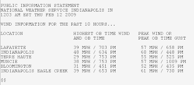
  A squall line of storms came through the area bringing a burst of heavy wind driven rain dropping visibility to less than 100 feet (30 meters). It was quite exciting to see, but only lasted about three minutes. After the squall passed, skies began to clear and sunshine returned. The winds were beginning to increase and by 6pm the winds were really howling. The top wind gust here at home was from the south at 47mph. Higher gusts were recorded around the area with Indianapolis having the strongest gust of 61mph.
Out of the storm, there was a tornado that touched down near Muncie, Indiana. The tornado was very weak, but still did considerable
 damage to this home and barn. Here is a report from the NWS in Indianapolis:
A National Weather Service survey team has determined that a small tornado touched down on Wednesday February 11 near 3:40 PM. The tornado touched down in Delaware county...near county roads 300 East and 550 South...which is about 5 miles southeast of Muncie...near the town of Medford.
The tornado was rated an EF-1 with approximately 100 mph winds. The tornado was approximately 100 feet wide and was on the ground for about two tenths of a mile.
This tornado dislodged a barn roof and
 damaged the roof of a single family home across the street.
This tornado is the first tornado of the year in Central Indiana.
No comments:
Post a Comment