The last few days have been very uneventful. We've lost a lot of the snow pack that we started out with after the last storm, the roads cleared completely, and the sun was visible off and on. Nothing too exciting to report. However, last night changed all of that. Forecasters had been mentioning that a very large storm would be hitting the center of the country this weekend, but for our area it would be only rain. A welcome change from all of the ice and snow that we've been having. However, the temperatures didn't warm as quickly as the forecast called for and so when the precipitation began to fall it fell as sleet, freezing rain, and snow.
At about 4pm yesterday (Saturday, February 24) the temperature was at 30 degrees and the first drops of rain began to fall. To our west and southwest a massive shield of heavy precipitation was moving east northeast towards us. Within 30 minutes, the freezing rain intensified putting a coat of ice on everything. Icicles were forming on the trees, power lines, and the deck. After about thirty minutes of freezing rain, the precipitation turned to all sleet. The sleet accumulated enough to cover the road, sidewalk, deck and bare patches of ground with a white coating. After about 30 minutes of sleet, the precipitation turned to giant snowflakes. I don't recall seeing snow flakes this large before. The flakes were so large that they cast a shadow on the ground in the orange glow from the security light as they fell. They were about the size of silver dollars. These snow flakes were very wet and heavy. The fell straight down and with some speed. Over the next couple of hours, the precipitation took many turns from snow, to sleet, to freezing rain. Eventually, the temperatures began to rise and the precipitation became plain rain. The damage had been done though and everything was coated with a thick two inch slushy mess.
At 9:45pm I noticed a car coming up the hill heading east. I'd seen the car in days past, but wasn't sure where they were from. Anyway, the car made it up the hill and got right in front of house when it could go no farther. I watched the car for a few minutes back down the hill to the corner and then try and head up the hill again. No luck. The thick layer of slush on the road, plus the light coating of ice underneath made the roads treacherous and nearly impassable. I finally went out to see if I could help get them up the hill. Once I got out there, they made it up the hill on their own pretty much. They stopped to thank me, but I deserved none. I felt really bad to find out that it was two older ladies and a baby. I wish I had gone out sooner rather than watch them struggle on the hill for ten minutes. It's just that the last time I went out to help someone get up the hill they were drunk. Anyway, I went back inside and watched to see if they made it up the next hill. They had trouble and I was just about to head out to help them when I saw that they eventually made it up the hill. It was not a good night to be out!!
Today, the weather has calmed down. The current temperature is 42 degrees with a high expected in the upper 40's. The county has yet to come by and scrape the slush off the road. I'm thinking that they won't. They'll probably let the temperature melt it, but then tonight it is supposed to drop below freezing. If they don't scrape it I imagine tomorrow morning will be a mess. Do I hear 2-hour delay? :-)
Sunday, February 25, 2007
Wednesday, February 21, 2007
Freezing Fog
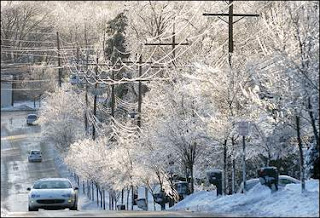
The fog redeveloped overnight and the temperature dropped to about 25. As a result, the fog froze on everything leaving a thin layer of ice. Listening to the county road crews on the scanner, many of the roads were in fact ice covered and slick. School started out on a 2-hour delay this morning, but was eventually closed.
Tuesday, February 20, 2007
Foggy Tuesday
Compared to the last several weeks, we experienced a heat wave today. Temperatures were in the 40's with some moderate rain. As a result of the warm air moving in and the rainfall, the fog developed very quick. By 3pm, visibility was very low. Likely less than 1/4 mile. However, by 7pm skies began to clear and the fog began to lift. The current temperature is around 35 degrees, but the temperatures is supposed to drop to 25 tonight. If there are areas with fog left over, it will become freezing fog.
Monday, February 19, 2007
February 13-14, 2007 Winter Storm
The following comes from the Wilmington NWS...
An intense winter storm developed over the Southern Plains and moved across the Ohio Valley on Tuesday, February 13, 2007. Widespread rain developed ahead of the storm late on Monday February 12. The moisture moved into colder air as it crossed into northern Kentucky, southern to snow, and dropped anywhere from 1 to 5 inches of snow on much of the region by daybreak Tuesday. As the storm intensified, it drew in warmer air from the south, which caused the snow to quickly change to sleet and freezing rain Tuesday morning and afternoon across much of the I-70 corridor and points south. Areas from Dayton to Columbus received several inches of sleet on top of the snow, which later turned into freezing rain with up to a quarter inch of ice on trees and power lines. Further south, snow had quickly changed to freezing rain Tuesday morning. This included areas from the northern Cincinnati suburbs into Wilmington and areas south of Columbus. The temperature never warmed above freezing across these areas, which allowed ice to accumulate to between a half inch and an inch. This resulted in significant tree damage and numerous power outages. Southern portions of Cincinnati and far northern Kentucky saw temperatures warm to near or slightly above freezing which alleviated some of the icing, but still allowed up to a quarter of an inch of ice accumulation and several downed tree limbs and power lines.
Further north, the intensifying storm caused the pressure gradient to tighten across western and northern Ohio and resulted in very strong winds with gusts up to 45 mph. This caused significant blowing and drifting of snow across areas from Troy to Marysville, and further north into Celina, Wapakoneta and Bellefontaine. As a result, road crews had a very difficult time keeping roads clear, and by Tuesday afternoon, travel across west central Ohio was nearly impossible. By Tuesday evening, a level 3 snow emergency had been declared in many counties in west central Ohio. The snow continued late Tuesday night, and by Wednesday morning had accumulated to anywhere from 8 to 15 inches. The wind caused snow to drift substantially, and in some cases drifts were over 4 feet high.
Click on any of the pictures below for a larger image.


.


The Thaw Begins
The temperature hit 45 today! Just about all of the packed ice and snow on the roads have melted. Also, it is obvious that the snow depth has diminished too. With temperatures forecast to be this warm or warmer over the next week, we may not have any snow left by next Monday.
Rain if forecast Tuesday afternoon and evening.
Rain if forecast Tuesday afternoon and evening.
Saturday, February 17, 2007
More than Four
A lot more snow fell today than what was predicted. Some were forecasting 1-3 inches while others said 2-4 inches. Actually, we had at least 5 inches of snow fall here today. It was a light and fluffy snow, so the ratio was likely higher than the typical 10:1.
Tonight, the snow is blowing around quite a bit. The winds are out of the northwest at about 20mph with gusts up to 30mph. Since the snow is so fluffy, the drifts are getting deep. This upcoming week should prove interesting with the warmer temperatures forecast. Will we see any flooding?
Tonight, the snow is blowing around quite a bit. The winds are out of the northwest at about 20mph with gusts up to 30mph. Since the snow is so fluffy, the drifts are getting deep. This upcoming week should prove interesting with the warmer temperatures forecast. Will we see any flooding?
Friday, February 16, 2007
Snow Advisory
More snow is on the way. An Alberta Clipper is heading southeast towards the area and is forecast to drop 2-4 inches of snow on the area. I think the heaviest snow will fall to our south.
From the NWS Indianapolis...
...SNOW ADVISORY IN EFFECT FROM MIDNIGHT EST /11 PM CST/ TONIGHT
TO 4 PM EST /3 PM CST/ SATURDAY...
THE NATIONAL WEATHER SERVICE IN INDIANAPOLIS HAS ISSUED A SNOW
ADVISORY...WHICH IS IN EFFECT FROM MIDNIGHT EST /11 PM CST/
TONIGHT TO 4 PM EST /3 PM CST/ SATURDAY.
A QUICK MOVING CLIPPER SYSTEM WILL PASS THROUGH CENTRAL INDIANA
AFTER MIDNIGHT TONIGHT. BY SATURDAY EVENING...2 TO 4 INCHES OF
SNOW CAN BE EXPECTED. SATURDAY NIGHT...WIND SPEEDS WILL INCREASE
TO 15 TO 20 MPH FROM THE NORTHWEST WHICH WILL CAUSE SOME BLOWING
AND DRIFTING OF SNOW.
From the NWS Wilmington...
THE NATIONAL WEATHER SERVICE IN WILMINGTON HAS ISSUED A SNOW
ADVISORY...WHICH IS IN EFFECT FROM 4 AM TO 8 PM EST SATURDAY.
A QUICK MOVING ALBERTA CLIPPER WILL DROP THROUGH THE OHIO VALLEY
ON SATURDAY. THIS WILL BRING SNOW TO THE REGION BEGINNING LATE
TONIGHT AND CONTINUING THROUGH SATURDAY. 2 TO 3 INCHES OF SNOW ARE
EXPECTED BY SATURDAY EVENING. NORTHWEST WINDS OF 15 TO 20 MPH ON
SATURDAY NIGHT MAY ALLOW FOR SOME BLOWING AND DRIFTING TO OCCUR.
A SNOW ADVISORY IS ISSUED WHEN SNOW IS FORECAST TO DEVELOP IN THE
AFFECTED AREAS, BUT ACCUMULATIONS ARE EXPECTED TO BE LIGHT. ANY
SNOW WOULD MAKE DRIVING AND WALKING DIFFICULT BUT NOT IMPOSSIBLE
ON UNTREATED ROADWAYS AND SIDEWALKS. WHEN TEMPERATURES ARE BELOW
FREEZING, MOTORISTS NEED TO BE ESPECIALLY CAREFUL ON BRIDGES AND
OVERPASSES WHERE SLIPPERY SPOTS CAN EASILY DEVELOP.
Thursday, February 15, 2007
Sunny / Cold Day
It seems we are back in the deep freeze. The recent snow and ice has helped keep temperatures quite cold during the day and very cold at night. With clear skies and light winds the temperature dropped to 1 above this morning and will likely drop below zero tonight. Temperatures are forecast to warm up considerably next week into the 40's and rain. That's going to make a slushy mess.
More Storm Information
From the Indianapolis NWS
February 12-14 Storm Summary
The largest snow event of the season struck central Indiana on February 12th through the 14th. The snow began during the evening of February 12th, moving from the southwest to northeast across Central Indiana. The snow continued at Indianapolis for nearly 30 hours, and when it was all done, during the early morning hours of February 14th, Indianapolis had received 8.5 inches of snow.
Blowing and drifting of snow became problematic during the evening of February 13th and during the early morning hours of February 14th. Snow drifts caused the most problems in the areas that received the most snow, mainly north of Interstate 70.
The low pressure system that produced the storm tracked along and south of the Ohio River across Kentucky which is an ideal storm track for heavy snow in central Indiana. Snow amounts with the storm were heaviest along a Lafayette to Muncie line. Many cities along this line received over a foot of snow. The largest amount of snow was measured in Lafayette, where 17 inches was measured by meteorologists at a television station. This ranks a tie for the second largest snowfall over a three day period in Lafayette. The largest snowfall in Lafayette was 20.5 inches on December 19-20, 1929.
If you click on the map below, you'll see the snow totals from across the state.

Wednesday, February 14, 2007
Blizzard / Ice Storm Aftermath
The Blizzard and Ice Storm of '07 is over. It didn't affect us so much, but north of I-70 up to 16 inches of snow fell with sustained winds of 30-35mph and south of us up to 3/4 of an inch of ice coated everything. Here are a few pictures I found on the Internet. There weren't many pictures of the blizzard, but there are sev eral
eral 

 pictures of the ice.


 eral
eral 

 pictures of the ice.


Tuesday, February 13, 2007
12-Hours of Sleet
Here are a couple of pictures I took today showing how thick the crust of ice and sleet is that fell today. There was about 4-5 inches of snow under the ice crust. The road is covered in this and makes it very difficult to drive on.


Still Ice
After my last post, the freezing rain began turning into more and more sleet. It appears now though that some tiny snow flakes are mixing in with the sleet. The precipitation is very light. If it were warm enough to have no doubt that this was just rain, you'd say it was sprinkling.
The snow plow headed west about an hour ago. It hasn't plowed heading east yet. The areas that were bare road after the plow went by is now white again from the sleet. Looks slippery.
The snow plow headed west about an hour ago. It hasn't plowed heading east yet. The areas that were bare road after the plow went by is now white again from the sleet. Looks slippery.
Snow and Ice
It began to snow last night. When I woke up this morning at 6:45 we had about 4 inches of new snow on the ground with freezing rain falling. The current temperature is 28.8F. The freezing rain continues to fall with maybe a little sleet mixed in. I can't see the sleet, but I hear it hit the windows every once in a while. I see that there is a glaze of ice on the trees though. Also, a big concern here, the power has blinked once. :-( I'll have more later this morning around noon.
Monday, February 12, 2007
Questions Questions Questions
Who knows what this storm is going to turn out. It's snowing out right now with a temperature of 31. Will the temp go up or down? Will we have rain, sleet, freezing rain, snow or a mix of them all? I guess time will only tell. School is closed for tomorrow in anticipation of the weather. I give up on reading and speculating about what might happen and so I'm just planning to write about what *has* happened from now on with this storm. More in the morning.
Sunday, February 11, 2007
Storm Track
Well, it would appear that the storm is tracking farther north according to current forecasts. The heaviest snow, up to 16 inches, will be north of I-70. Here in Franklin county, the forecast is calling for about 4-6" of snow with 1" of ice. This is *not* the storm I was hoping for. One forecaster from Louisville, KY posted in his blog this evening that he is not convinced with the more northern track of the storm. If that is the case, then we will have less sleet and ice and more snow. I'm sure that by tomorrow evening, the storm track will be narrowed down and we'll know what to expect. Right now the track could go either way from what I understand.
Winter Storm Watch
Another winter storm is heading our way. This storm is much stronger and has the potential to put down snow in the double digit range! Forecasters have been suggesting that the storm is trending further north. That's not all that great though. The heavy snow will be on the north side of the storm of course with sleet and freezing rain in the center. It looks like we will have a lot of snow here, but it could be cut down by some ice. I personally don't want the ice because it causes more problems than the snow and doesn't look as nice. Besides, this storm will have wind with it too and if we get snow with a little ice on top it won't drift very well.
Here's a map of the winter storm watch as of this morning. I don't seen any ice storm warnings at this time though.

Here's a map of the winter storm watch as of this morning. I don't seen any ice storm warnings at this time though.

A WINTER STORM WATCH REMAINS IN EFFECT FROM MONDAY AFTERNOON
THROUGH LATE TUESDAY NIGHT.

A LOW PRESSURE SYSTEM WILL MOVE OUT OF THE SOUTHERN PLAINS ON
MONDAY AND INTO THE LOWER TENNESSEE VALLEY ON TUESDAY. ABUNDANT
GULF MOISTURE WILL BE PULLED NORTH INTO THE OHIO VALLEY ON MONDAY
NIGHT AND TUESDAY AS THE LOW PASSES TO THE SOUTH OF THE REGION.
THIS WILL BRING WINTRY PRECIPITATION TO THE REGION.

SOME LIGHT PRECIPITATION WILL BE POSSIBLE ON MONDAY AS A COLD
FRONT DROPS SOUTH ACROSS THE AREA. TEMPERATURES MAY ACTUALLY WARM
ENOUGH FOR THIS TO BE A SNOW AND RAIN MIX IN SOME LOCATIONS ON
MONDAY AFTERNOON AND EVENING. SOME LIGHT SNOW ACCUMULATION IS
POSSIBLE DURING THIS TIME. COLDER AIR MOVING IN FROM THE NORTH
WILL CAUSE THE PRECIPITATION TO CHANGE OVER TO ALL SNOW ON MONDAY
NIGHT...EXCEPT IN PARTS OF NORTHERN KENTUCKY WHERE SLEET WILL
REMAIN POSSIBLE THROUGH THE NIGHT. AS THE LOW MOVES THROUGH THE
TENNESSEE VALLEY ON TUESDAY...HEAVIER PRECIPITATION AND SOME WARM
AIR ALOFT WILL SPREAD NORTH. THE LATEST INDICATIONS ARE THAT A MIX
OF SNOW AND SLEET WILL OCCUR ACROSS NORTHERN KENTUCKY INTO SOUTH
CENTRAL OHIO...WITH FREEZING RAIN POSSIBLE AS WELL. ELSEWHERE THE
PRECIPITATION WILL FALL AS ALL SNOW. THE PRECIPITATION WILL
FINALLY WIND DOWN ON TUESDAY NIGHT AS THE STORM MOVES OFF TO THE
EAST. THERE IS THE POTENTIAL FOR 6 TO 10 INCHES OF SNOW. IN
ADDITION...SIGNIFICANT SLEET AND FREEZING RAIN ACCUMULATION IS
POSSIBLE IN NORTHERN KENTUCKY AND SOUTH CENTRAL OHIO.

THERE STILL IS SOME UNCERTAINTY WITH THE TRACK OF THE STORM AND
THUS HOW MUCH PRECIPITATION WILL OCCUR. IN ADDITION...THE LOCATION
WHERE THE PRECIPITATION IS EXPECTED TO TRANSITION FROM ALL SNOW
TO A MIXTURE OF SNOW AND ICE MAY CHANGE.
Thursday, February 8, 2007
Sunny and Cold
Nothing too exciting today. The morning low did drop below zero. I think it went down to about -3. They're beginning to talk about a storm early next week. Let's hope it's another snow storm.
Wednesday, February 7, 2007
Sunny and Cold Day
The day started off sunny, but high thin clouds rolled in as the day went on. It was also a cold day. The new snow cover seems to have reflected a lot of the energy back into space. Maybe we'll get to below zero tonight. We have a 2-hour delay in the morning for school.
On to the next storm.
On to the next storm.
The Aftermath
It looks like we were right in the midst of the heaviest snow. Here are some snowfall reports from the area...
PUBLIC INFORMATION STATEMENT...SUMMARY
SPOTTER REPORTS
NATIONAL WEATHER SERVICE WILMINGTON OH
947 PM EST TUE FEB 6 2007

THE FOLLOWING ARE UNOFFICIAL OBSERVATIONS TAKEN DURING THE PAST 12 HOURS
FOR THE STORM THAT HAS BEEN AFFECTING OUR REGION.  APPRECIATION IS EXTENDED
TO HIGHWAY DEPARTMENTS...COOPERATIVE OBSERVERS...SKYWARN SPOTTERS
AND MEDIA FOR THESE REPORTS.  THIS SUMMARY IS ALSO AVAILABLE ON OUR
HOME PAGE AT WEATHER.GOV/ILN

********************STORM TOTAL SNOWFALL********************

LOCATION          STORM TOTAL    TIME/DATE    COMMENTS
                SNOWFALL       OF
                (INCHES)   MEASUREMENT

INDIANA

..DEARBORN COUNTY

LAWRENCEBURG           6.0   745 PM   2/6   COUNTY GARAGE

..FAYETTE COUNTY

CONNERSVILLE           6.5   735 PM   2/6
CONNERSVILLE           5.3   900 PM   2/6   SPOTTER REPORT

..FRANKLIN COUNTY

BROOKVILLE             7.0   733 PM   2/6

..OHIO COUNTY

RISING SUN             6.0   737 PM   2/6   COUNTY GARAGE

..RIPLEY COUNTY

VERSAILLES             5.5   744 PM   2/6   COUNTY GARAGE

..SWITZERLAND COUNTY

VEVAY                  5.0   741 PM   2/6

..UNION COUNTY

LIBERTY                6.5   739 PM   2/6

..WAYNE COUNTY

CENTERVILLE            7.0   905 PM   2/6   SPOTTER REPORT


Tuesday, February 6, 2007
7 Inch Snowfall
The snow today was impressive for a clipper system in the northwest flow. I measured the snow depth in several areas around the house and came up with an average of 7". It was very light though which is good for shoveling. The snow came to an end around 6pm. At 8pm some very light freezing drizzle was falling, but that's not really going to have an impact on much.
Sanes Creek is totally snow covered. The county came through around 3pm and plowed both sides of the road, but with snow falling at an inch per hour it quickly became covered again. Naturally, school is closed again for Wednesday. I'm sure we'll have school Thursday, but it may be a delay.
I'll take a few pictures tomorrow and post.
And the Snow Begins
The snow began falling at 11:00 am. It started out with just a few flurries here and there, then steadily increased in intensity to moderate snowfall. The temperature out is now at 12 and the snow is definitely *not* melting as it hits the ground. I think we'll see every inch of snow out of this one. It is a very fine and light snow which means even if we get just a *little* bit of wind it will likely blow the snow around and drift.
Jude Redfield on channel 13 out of Indianapolis says snowfall rates will hit 1-2" per hour in the heaviest bands. He also states that the heaviest band of snow will follow the I74 corridor.
A lot of schools that were on 2-hour delays due to the cold earlier this morning are now dismissing early. Looks like Franklin County schools got it right from the beginning. What a waste today would have been had we gone in to school only to be sent home two hours later!
 Here are a few pictures from Indianapolis, Cincinnati, and here. The first two are from Cincinnati (lower deck of Brent Spence bridge/I75 S at Towne Street) and the last is from Indianapolis (I 465S at I65). The final picture is from the house. It's obvious to see that the snow hasn't started in Cincinnati like it has here yet.
I'll post more this evening.


Jude Redfield on channel 13 out of Indianapolis says snowfall rates will hit 1-2" per hour in the heaviest bands. He also states that the heaviest band of snow will follow the I74 corridor.
A lot of schools that were on 2-hour delays due to the cold earlier this morning are now dismissing early. Looks like Franklin County schools got it right from the beginning. What a waste today would have been had we gone in to school only to be sent home two hours later!
Here are a few pictures from Indianapolis, Cincinnati, and here. The first two are from Cincinnati (lower deck of Brent Spence bridge/I75 S at Towne Street) and the last is from Indianapolis (I 465S at I65). The final picture is from the house. It's obvious to see that the snow hasn't started in Cincinnati like it has here yet. I'll post more this evening.


Before the Snow
School was placed on a 2-hour delay last night due to the cold, but was canceled this morning in what I can only guess is the anticipation of the heavy snow that will likely begin falling around noon today.
The morning started off sunny, but the clouds are quickly streaming in and the skies are beginning to turn more and more gray. The morning low was 4 below zero, but with a very light southerly wind the temperature is rising. The forecast calls for a high of 15 today with 3-6 inches of snow.
I'll post again when the snow begins to fall.
Monday, February 5, 2007
Heavy Snow Warning
From the NWS in Wilmington, OH...
**********
It appears this will be our largest snowfall of the winter. I'm not certain, but I don't believe there will be a lot of moisture with this system. The depth of the snow will come from the cold temperatures which will make the liquid to snow ratio very high.
Speaking of temperatures, the low this morning hit 4 below zero. This was the coldest temperature so far this winter. It's already at 1 below zero as I type this and skies are clear. We'll see if we can top this morning's low.
**********
A HEAVY SNOW WARNING REMAINS IN EFFECT FROM 1 PM TUESDAY TO 1 AM*********
EST WEDNESDAY. A WIND CHILL ADVISORY REMAINS IN EFFECT UNTIL 1 PM
EST TUESDAY.
COLD TEMPERATURES IN THE SINGLE DIGITS TONIGHT WILL COMBINE WITH
WIND SPEEDS UP TO 10 MPH...PRODUCING WIND CHILLS FROM 10 TO
15 BELOW ZERO.
A CLIPPER SYSTEM WILL BRING SNOW TO THE AREA LATE TUESDAY MORNING
INTO THE EVENING. WITH THE ARCTIC AIR IN PLACE ACROSS THE
REGION...IT IS LIKELY THAT 3 TO 5 INCHES OF SNOW WILL FALL DURING
THIS TIME.
It appears this will be our largest snowfall of the winter. I'm not certain, but I don't believe there will be a lot of moisture with this system. The depth of the snow will come from the cold temperatures which will make the liquid to snow ratio very high.
Speaking of temperatures, the low this morning hit 4 below zero. This was the coldest temperature so far this winter. It's already at 1 below zero as I type this and skies are clear. We'll see if we can top this morning's low.
Sunday, February 4, 2007
The Frozen Tundra
There wasn't anywhere near the traffic on the road today as a normal day. Apparently, people are staying indoors to avoid the cold. It was very cold today. The morning low started out at -0.2 below zero. The wind wasn't nearly as strong as yesterday, but strong enough. The high today was 12 above. The coldest wind chill was -14.
Saturday, February 3, 2007
Arctic Outbreak 2
Today has been a cold and windy day. I was expecting a lot of cloudiness today, but it was mostly sunny for most of the day. The sun was shining bright and strong this morning, but began to increase around noon. By 1pm a burst of heavy snow arrived but quickly past and then skies cleared again.
The biggest story for today would have to be the winds. There were several gusts over 30mph today driving the wind chill into the single digits for the entire day. There was a blowing snow advisory for counties north of I70, but that has since expired. A wind chill advisory is in effect though until noon Sunday.
I looked back through the records that I have kept over the years, and this is the coldest February weather since 2003. During that month, our lowest temperature was zero. I imagine we'll be colder than that this year.
Friday, February 2, 2007
Arctic Outbreak
More snow showers came through this morning. We never have anymore than a half inch of snow with these snow showers. It's just enough to whiten the ground, cover the roads to make them white and cause a few slick spots.
It seems that the big story for the next few days will be the cold. We are already down to 7 above this evening and the dew point is at -4. I've always heard that the dew point in the evening is a good indicator of what he low temperature will be in the morning. We'll see. I doubt that it gets down to -4, but then again the forecast called for a low of 10 tonight.
Tomorrow, the wind is supposed to pick up when the arctic front comes through. I saw that we could have gusts up to 40mph. That should make for some good wind chills.
No one sees any significant snow on the way. I think we'll have at least one 4"+ snowfall before the winter is over. I hope anyway.
Thursday, February 1, 2007
Cold and cloudy with snow showers
Just a cold and cloudy February day with some snow. We had about a half inch of snow fall today. It was enough to make the roads slick while it was falling, but it melted eventually since there is so much salt left on the roads. Another round of light snow is expected tonight, but I don't think it will amount to much either. Maybe the next one will get us.
Subscribe to:
Posts (Atom)