 The ice storm on Friday night left about an 1/8th of an inch of ice coating everything. Sleet fell on top of that making for a hard pack of ice on roadways. The temperature on Saturday only reached 22 degrees and it was cloudy, so there was absolutely no melting. Back roads are still icy this afternoon, but softening up quite a bit as temperatures are up to 32 degrees at 1:47pm.
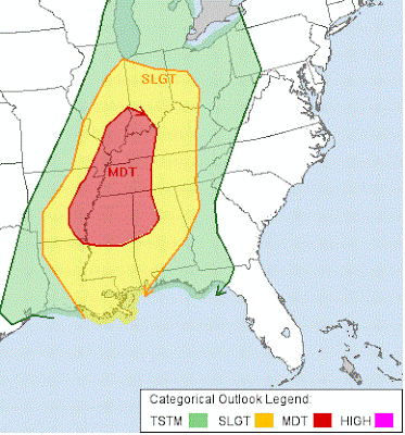
The next storm promises to bring the opposite side of the spectrum to the region with strong storms. The Storm Prediction Center has placed southwest Indiana in a moderate risk for sever storms while the rest of Indiana is in a slight risk for severe weather. The heaviest storms should enter the state late Sunday night into early Monday morning. Threats include strong winds, hail, and possible tornadoes.
No comments:
Post a Comment